

by Ila Rae Boley*, Master’s Degree Candidate, The University of Texas at Austin
Microbialites in the Sapinhoa Oil Field: Reservoir Characterization and Financial Analysis for Hydrocarbon Production
The purpose of this Master’s Degree research study is to evaluate microbial carbonates in the pre-salt Sapinhoa field of the Santos Basin, both for the purpose of hydrocarbon production and Carbon Capture Utilization and Storage (CCUS). This blog post discusses the hydrocarbon production aspects of the current study.
The Santos Basin has been a site of prolific hydrocarbon discoveries within the last two decades despite the heterogeneity present in its carbonate reservoirs. Recent discoveries have shed light on carbonate reservoir production, including the Tupi (Lula) and Sapinhoa fields. This research integrates geologic and financial analysis of the Sapinhoa field using several datasets provided by: ION Geophysical, GeoPost, the Bureau of Economic Geology (The University of Texas at Austin), and the National Agency of Petroleum, Natural Gas, and Biofuels (ANP).
Through the integration of 3-D seismic data, well logs, core data, and drilling reports, this study evaluates the geologic structure, reservoir characteristics, and potential hydrocarbon production. Research results provide an opportunity to model several optimization strategies and assess how the consortium operating in the Sapinhoa field to date might optimize the production of the field.
The Sapinhoa field, originally termed Guara, is located in the central most portion of the Santos Basin, 310 km off the Brazilian coast in deep water (2,153 m).[1] Petroleum-rich formations within the Sapinhoa field are part of the Guaratiba Group, a geological group consisting of three formations situated in the syn-rift and sag-sequence of the basin. These layers overlie basement and volcanic facies. Organic-rich lacustrine shale source rock and coquina facies belonging to the Itapema Formation are part of the syn-rift sequence. The overlying sag sequence contains the Barra Velha carbonate reservoir interval and the Arriri evaporite layer.

Within the field, hydrocarbons migrated from the organic-rich shale source rocks to carbonate sag facies through NE-SW trending fault pathways[1]. The main hydrocarbon accumulation (reservoir interval) is located on the Outer High that runs through the basin, indicative of an extensional microbial platform, just below the base of salt (Arriri Formation).[2] The Outer High serves as the location for several pre-salt reservoirs, and previous research suggests that basement highs are a key component of the Santos Basin petroleum system.[3] In addition to carbonate platforms, microbial buildups along localized fault zones are indicative of optimal reservoir facies for hydrocarbons.3 The base of the Arriri salt provides structural closures for these reservoirs, as the evaporite layer serves as an impressive seal for hydrocarbons that have migrated up dip.


Data from GeoPost and ANP facilitated the definition of volumetric parameters/reservoir characteristics to quantify the original oil in place (OOIP) and estimated ultimate recovery (EUR) of the field, exceeding two billion stock tank barrels. Volumetric analysis indicates a successful hydrocarbon producing field including a thick net pay zone, high porosity, and oil saturated reservoir. Results from this study compared to production rates of pre-salt mature fields should allure further exploration and investments in the relatively newly discovered Santos Basin.
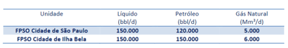
One of the critical questions this study evaluated was the impact of adding an additional FPSO to the Sapinhoa field. Currently, there are two FPSOs operating in the field, limiting production capacity of the seventeen producer wells, and as a result reducing annual oil production throughout the life of the project. In order to quantify annual and cumulative oil production, estimated ultimate recovery was determined through volumetric analysis and Monte Carlo Simulation was performed to determine a high and low case estimate of reserves. Oil production was then forecasted using a well decline model with typical initial production rates for pre-salt fields, shown in the Table below. Brazilian pre-salt fields contain some of the most productive wells globally and therefore the decision to implement additional FPSOs may become a topic of interest as exploration continues in the pre-salt polygon.
| Estimated Ultimate Recovery Distribution | Excellent Well Count [Initial Production 38 kbd] | Good Well Count [Initial Production 30 kbd] | Marginal Well Count [Initial Production 25 kbd] | Total Producer Well Count |
| Low Case EUR | 3 | 5 | 7 | 15 |
| Base Case EUR | 4 | 6 | 7 | 17 |
| High Case EUR | 5 | 7 | 8 | 20 |

*Ila Rae Boley is completing a Master’s Degree at The University of Texas at Austin, Jackson School of Geosciences in the Energy and Earth Resources Program.
[1] Wikimedia Foundation. (2021, December 21). Santos Basin. Wikipedia. Retrieved January 6, 2022, from https://en.wikipedia.org/wiki/Santos_Basin
[2] JPT. (2016, September 26). Sapinhoá Field, Santos Basin presalt: From design to execution and results. JPT. Retrieved January 5, 2022, from https://jpt.spe.org/sapinhoa-field-santos-basin-presalt-design-execution-and-results
[3] Kattah, S., & Balabekov, Y. (2015, August). Seismic facies/geometries of the pre-salt limestone units and newly-identified exploration trends within the Santos and Campos basins, Brazil. Society of Exploration Geophysicists. Retrieved March 1, 2022, from https://www.researchgate.net/publication/301433045_Seismic_faciesgeometries_of_the_pre-salt_limestone_units_and_newly-identified_exploration_trends_within_the_Santos_and_Campos_basins_Brazil
[4] Ysaccis, R., El-Toukhy, M., & Moreira, L. B. (2019, August). Maximizing the value of seismic data for a better regional … Brazilian Geophysical Society. Retrieved March 18, 2022, from https://sbgf.org.br/mysbgf/eventos/expanded_abstracts/16th_CISBGf/Maximizing%20the%20value%20of%20seismic%20data%20for%20a%20better%20regional%20understanding%20and%20exploration%20assessment%20in%20the%20Santos%20Basin,%20Brazil.pdf
[5] The National Agency of Petroleum, Natural Gas and Biofuels (ANP). (2017). Plano de Desenvolvimento Aprovado Reunião de Diretoria nº 881 de 12/04/2017 – Resolução nº 223/2017. GeoPost. Retrieved March 24, 2022, from https://www.anp.gov.br/SITE/acao/download/?id=8419

About the Author:
Ila Boley received a Master’s of Science in Energy and Earth Resources from The University of Texas at Austin in May 2022. While attending the University her Master’s research focused on reservoir characterization and financial analysis of microbial carbonates in the pre-salt Sapinhoa Oil Field. Ila now works as a Geoscience Intern at ExxonMobil in their Houston, Texas office.